When homeowners or real estate investors see a property listed in FEMA's Zone X (minimal flood risk zone), they often assume the property is safe from flooding concerns. Unfortunately, this assumption can be costly. Despite FEMA's zone designations, many properties face significant flood risks that aren't captured by outdated or oversimplified flood maps.
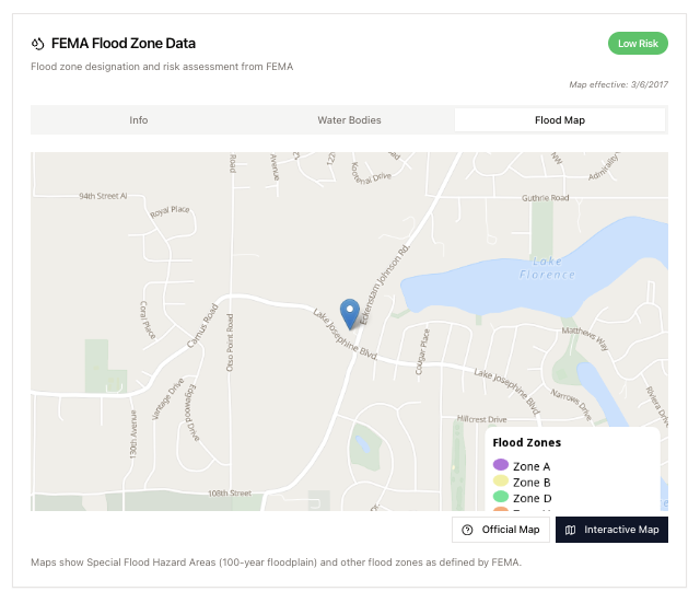
FEMA maps often mark properties as low risk despite their proximity to water bodies
Why FEMA Flood Maps Don't Tell the Whole Story
FEMA flood maps, while valuable, have several limitations that can obscure actual flood risks:
- Outdated Information: Many FEMA maps haven't been updated in 5-10 years or more, failing to account for recent development, climate changes, or erosion patterns.
- Binary Classification: Properties are often classified as either "in" or "out" of flood zones, missing the nuanced spectrum of actual risk levels.
- Limited Risk Factors: Traditional maps focus primarily on river and coastal flooding without adequate consideration for other water-related risks.
- Climate Change Impacts: Historical data used for many maps doesn't account for changing precipitation patterns and extreme weather events.
"Nearly 40% of NFIP flood damage claims between 2014-2018 came from properties outside designated high-risk flood zones."
— Federal Emergency Management Agency (FEMA)
Risk Rating 2.0: A More Accurate Approach
Recognizing these limitations, FEMA implemented Risk Rating 2.0 in October 2021, moving away from the zone-based approach to a property-specific risk assessment.
This new methodology considers:
- Property characteristics (foundation type, first floor height, etc.)
- Replacement cost value
- Distance to water sources
- Elevation relative to nearby water bodies
- Multiple flood types (river overflow, storm surge, heavy rainfall, etc.)
Hidden Flood Risk Factors Property Owners Should Consider
Beyond FEMA designations, several critical risk factors can impact flooding potential:
Risk Detection Example
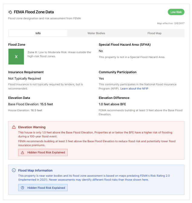
For the property shown below, FEMA designated it as Zone X (minimal flood hazard), but our advanced algorithms detected significant flood risk factors that FEMA missed—including proximity to Lake Anderson and elevation just 1.0 feet above base flood elevation, well below the recommended 3-foot safety margin. Crucially, we also identified that this community's flood maps have not been updated under Risk Rating 2.0, leaving homeowners with outdated risk assessments that don't reflect current conditions or methodologies.
Our comprehensive analysis goes far beyond FEMA's basic assessment to identify hidden flood risks
1. Proximity to Water Bodies
Even if a property sits outside a designated flood zone, proximity to any water body increases risk. Properties within 1/4 mile of lakes, rivers, streams, or even drainage ditches face elevated flood potential during heavy rain events.
Our platform uses advanced geospatial analysis to detect all water bodies near a property—even minor ones often overlooked in traditional assessments. We measure precise distances to each water source, evaluate elevation differentials, and incorporate these metrics into our proprietary risk algorithm. This detailed proximity data is surfaced directly in our reports, giving you visibility into factors that most assessments miss.
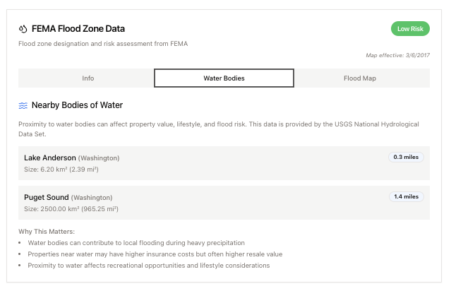
Our reports precisely measure distance to all nearby bodies of water—this property is only 0.3 miles from Lake Anderson
It's worth noting that proximity to water isn't all negative—waterfront or water-view properties typically command higher market values and provide recreational opportunities, potentially enhancing quality of life through boating, swimming, fishing, and scenic views.
If you're considering purchasing a home near water, the key is taking a balanced and informed approach. By understanding the specific risks, implementing appropriate mitigation strategies, and preparing for "just in case" scenarios, you can enjoy the benefits of waterfront living while protecting your investment. Our reports help you navigate this balance by identifying specific mitigation opportunities that can lower insurance premiums and reduce potential damage.
2. Property Elevation and Drainage Patterns
A property's elevation relative to surrounding areas is crucial. Low-lying properties or those at the bottom of slopes collect water from higher elevations. Poor drainage infrastructure in the neighborhood can exacerbate these issues.
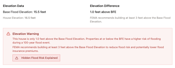
Our elevation analysis flags properties with insufficient height above flood levels—this house is 2 feet below FEMA's minimum recommendation
3. Local Development Changes Coming Soon
New construction, especially large developments, can fundamentally alter watershed dynamics. When natural landscapes are replaced with impervious surfaces (concrete, asphalt), water that previously absorbed into the ground becomes runoff, potentially affecting properties downstream.
4. Historical Flooding Events Coming Soon
Some areas have experienced flooding despite not being in designated flood zones. Historical flood data reveals patterns that FEMA maps might miss, especially for flash flooding from intense rainfall events.
Key Insight
PropertyInsights 101 reports include comprehensive flood risk analysis beyond FEMA designations, examining property-specific factors like elevation, distance to water bodies, soil permeability, and historical flooding patterns to provide a more accurate flood risk assessment.
Financial Implications of Overlooked Flood Risks
The financial impact of hidden flood risks can be substantial:
- Unexpected Insurance Costs: Under Risk Rating 2.0, many properties previously in "safe" zones are seeing significant premium increases as their true risk is recognized.
- Property Value Impacts: As flood risk information becomes more transparent and accurate, properties with higher risk may see market value decreases.
- Uninsured Losses: Property owners who assume they're safe without flood insurance face potentially devastating uninsured losses when flooding occurs.
- Renovation Requirements: After flood damage, properties often require significant upgrades to meet current building codes.
The Dramatic Impact of Elevation on Insurance Premiums
Property elevation relative to the Base Flood Elevation (BFE) has a dramatic impact on flood insurance costs. According to data from Wai Hālana (Hawaii's Flood Hazard Awareness newsletter), even a single foot of elevation difference can result in thousands of dollars in annual premium differences:
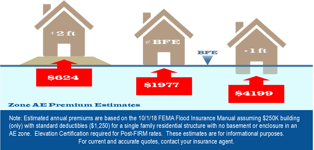
Source: Wai Hālana - Hawaii's Flood Hazard Awareness Newsletter. Data based on FEMA Flood Insurance Manual for a $250K single-family home with standard deductibles in Zone AE.
As shown above, a property just 1 foot below BFE can face annual premiums of $4,199. This is nearly 7 times higher than the $624 premium for a similar home built 2 feet above BFE. This stark difference highlights why understanding your property's true elevation profile is critical for financial planning.
PropertyInsights 101 reports identify these elevation factors and can help homeowners understand potential mitigation options to reduce both risk and insurance costs.
How Property Buyers Can Identify True Flood Risk
For a more complete understanding of flood risk:
Research Phase
- → Look beyond FEMA flood maps to property-specific flood risk tools
- → Consult local flood history records through county offices
- → Review comprehensive reports that analyze multiple flood risk factors
On-Site Assessment
- → Speak with longtime neighborhood residents about water issues
- → Inspect the property during heavy rain to observe drainage patterns
- → Consider a professional hydrological assessment for high-value properties
Conclusion
FEMA's flood zone designations provide a starting point for understanding flood risk, but they shouldn't be your only resource. By examining property-specific factors and utilizing modern risk assessment tools, buyers and owners can gain a more accurate understanding of their true flood risk. This knowledge enables better insurance decisions, appropriate mitigation strategies, and more informed property investments.
For the most comprehensive property risk assessment including detailed flood risk analysis, PropertyInsights 101 provides in-depth reports that go beyond traditional flood maps to evaluate your property's true risk profile.